Statewide :: News & Press :: Interactive Map :: Map Poster :: About the Map :: Landsat Lake Images
 Featured in WisconsinWeek and the Milwaukee Journal-Sentinel |
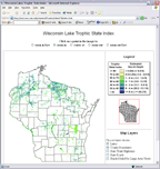
Results of Wisconsin's First Statewide |
| Pan and Zoom your way Across the State This interactive web map presents the research results in an easy to use interface. Users can zoom-in and -out and turn layers of information on and off. It is like "MapQuest" for Wisconsin lake water clarity. (Best viewed with IE 5.x or greater, NN 4.x or greater) Click here for info about the map |
|
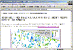
| Press Release - 13 January 2003 RESEARCHERS TRACK LAKE CLARITY FROM SPACE MADISON – Assisted by hundreds of volunteers around the state, University of Wisconsin-Madison researchers and their cooperators have developed a method of assessing the water quality of Wisconsin's lakes from space. Using images captured 438 miles above the earth, they have completed the first satellite-based inventory of the clarity of the largest 8,000 lakes in the state. The inventory is available to the public in map form on the Web, where it is possible to zoom in for a close look at your favorite lake or group of lakes... |
|
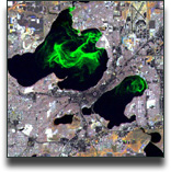
 Image Gallery |
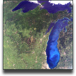
Landsat Image Gallery - Lake Images from Space Satellite imagery provides researchers with valuable tools for assessing a wide range of natural resource issues. This image gallery provides examples of images used by scientists at the University of Wisconsin-Madison to assess lake water clarity. An additional gallery focuses on the southern portion of Lake Winnebago at Fond du Lac. |
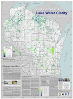 Map Poster (4.13 MB pdf file) |
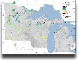
Printable* award-winning** poster of Wisconsin's
Lake Water Clarity: Measured by Satellite Wisconsin has nearly 15,000 lakes. This 36" x 48" map shows the estimated clarity, or transparency of the 8,000 largest of those lakes as measured by satellite remote sensing. It is the first ever complete map of water clarity for the State of Wisconsin with such detail. Click here for webpage version of the map text. *Full-resolution = 36" x 48" at 150 dpi and is 4.13 MB in file size. Click thumbnail to display with Adobe Acrobat Reader. If you would rather not use your browser plug-in, you can download the file for viewing and printing later with the stand-alone Acrobat Reader. Here's how: Windows (IE): Right-click thumbnail to "save target as..." Macintosh (NN or Safari): Click-hold thumbnail to "download link to disk" ** Awarded "Best in Class" for Map Poster category at the 2003 Wisconsin Land Information Association (WILA) meeting in Milwaukee. |
Related Links
|
|